TorontoOntario · 36 tours
 Niagara FallsOntario · 25 tours
 New York CityNew York · 30 tours
 Las VegasNevada · 8 tours
 San FranciscoCalifornia · 16 tours
 VancouverBritish Columbia · 17 tours
 DubaiUAE · 54 tours
 Abu DhabiUAE · 5 tours
 Buenos AiresArgentina · 23 tours
 AthensGreece · 31 tours
 AucklandNew Zealand · 38 tours
 CancunMexico · 54 tours
No destinations match “”. Try searching all tours instead — that search understands full questions, not just place names.
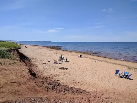
A Prince Edward Island beach famous for its 'Singing Sands' — high-quartz-content sand that squeaks underfoot when walked on in dry conditions.
Visitor guide
Basin Head Provincial Park sits on the eastern shore of Prince Edward Island, about 13 kilometres east of the town of Souris. It is best known as the Singing Sands, a pale, silica-rich beach whose dry sand squeaks underfoot, and it also protects a tidal channel that is home to a seaweed found nowhere else. For a day out from Charlottetown it combines a beach, a working-harbour museum and a small piece of marine science.
The beach takes its nickname from the sound its sand makes. Tourism PEI and Wikipedia both attribute the effect to the sand's high silica content: on a dry, sunny day, dragging your feet through the sand or rubbing it together produces a high-pitched squeak. Wikipedia describes the sand as geologically unusual for the area, though it is worth treating that as a local description rather than a precise scientific ranking. The sound fades when the sand is damp, so the effect is best on the dry upper beach.
A narrow tidal channel that locals call the run divides the beach into two sections. A bridge crosses it and has long been an informal spot for jumping and diving, although the province has at times restricted access to the wharf and bridge after storms filled the channel with sand, so conditions change from year to year.
The name refers to the wide, hollow, bowl-like shape of the shoreline. The area was long a productive fishing ground. Records summarised on Wikipedia say a harbour and wharf were authorised in 1937, with extensive dredging that built up the large dunes still seen today; the harbour opened in 1938 and was dredged again in 1959. At its busiest, around 25 to 30 boats fished from Basin Head, with up to twenty fishermen's shacks and a bunkhouse on the cape.
That working past is told at the Basin Head Fisheries Museum, which opened in 1973 as part of the PEI Museum and Heritage Foundation and is centred on a fish cannery building completed in 1941. Major renovations in 1995 and 1996, led by the Eastern Kings Development Association, added the boardwalk to the beach, along with gift shops, food service and a children's play village.
Behind the dunes, the tidal lagoon and inner channel hold a distinctive form of Irish moss (Chondrus crispus). Fisheries and Oceans Canada says this form is thought to exist only within Basin Head. It is unusually large, has a high carrageenan content, spreads by fragmentation rather than spores, and depends on blue mussels for attachment. To protect it, the federal government created the Basin Head Marine Protected Area under the Oceans Act, covering roughly 9 square kilometres between Souris and East Point. DFO's annual reports give the designation date as September 26, 2005, though one older management document says October 11, 2005. The inner channel has the highest level of protection, which is why you are asked to keep out of restricted areas and respect posted signs.
Souris is the closest town, and the eastern end of the Island lies beyond it. On a private tour, a driver handles the long run from Charlottetown, collects you at your door and can fit Basin Head into a wider eastern PEI day at your own pace.
See every tour and attraction we cover in Charlottetown.