TorontoOntario · 36 tours
 Niagara FallsOntario · 25 tours
 New York CityNew York · 30 tours
 Las VegasNevada · 8 tours
 San FranciscoCalifornia · 16 tours
 VancouverBritish Columbia · 17 tours
 DubaiUAE · 54 tours
 Abu DhabiUAE · 5 tours
 Buenos AiresArgentina · 23 tours
 AthensGreece · 31 tours
 AucklandNew Zealand · 38 tours
 CancunMexico · 54 tours
No destinations match “”. Try searching all tours instead — that search understands full questions, not just place names.
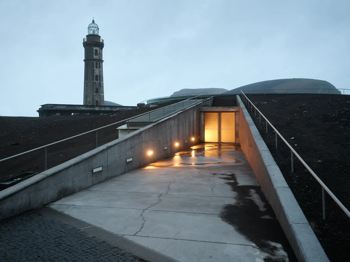
The site of a 1957-58 eruption on Faial Island that buried a lighthouse in ash and reshaped the island's coastline, now an interpretation centre built into the volcanic rock itself.
Visitor guide
Capelinhos is a volcano on the western coast of Faial Island in the Azores, Portugal, formed during a 13-month eruption between 1957 and 1958. The eruption buried the area around a lighthouse in ash and added new land to the island, and today the site is a landmark with a visitor centre.
According to Wikipedia, Capelinhos is a monogenetic volcano on the western end of Faial. Its name comes from Capelo plus a diminutive, meaning little cape. It belongs to the Capelo Volcanic Complex, which includes 20 scoria cones and lava fields, and its highest point is 501 metres. Wikipedia notes it can be considered the westernmost point of Europe, though other Azorean islands lie farther west on the North American Plate.
The eruption ran from 27 September 1957 to 24 October 1958. Before it began, about 200 earthquakes were recorded in the preceding days, and on 23 September the sea off the point began to boil. Whale spotters saw the ocean churning and alerted the lighthouse keepers when the submarine eruption started on 27 September. The first, Surtseyan phase lasted until 13 May 1958, followed by a Strombolian phase that ran until 24 October. By 10 October a new island about 600 metres across and 30 metres high had formed, and it later grew before disappearing into the sea. A second island formed in November and became joined to Faial by an isthmus.
The eruption enlarged Faial by about 2.4 square kilometres. Ash fell on land within days, and about 300 houses were destroyed in the parishes of Capelo and Praia do Norte, and around 2,000 people were evacuated. No deaths were reported. The lighthouse at Ponta dos Capelinhos marked the cape's western limit, and ash filled the space between the cone and the lighthouse. It is now a ruin and a tourist landmark alongside the visitor centre.
Because of close ties between Portugal and the United States, many residents emigrated. The Azorean Refugee Act of 2 September 1958 authorised the emigration of 1,500 people, and the population of Capelo fell by about 50 percent. Wikipedia describes Capelinhos as the first submarine eruption documented from beginning to end, and in October 2022 the International Union of Geological Sciences included it among its first 100 geological heritage sites. Fifty years later, no trees or bushes were found on the volcano.
Faial itself covers about 173 square kilometres and is known as the Blue Island, a nickname traced to a 1926 description by writer Raul Brandao of the hydrangeas that bloom along its roads in summer. Its central caldera is nearly circular, with a perimeter of about 2 kilometres and a depth of roughly 400 metres below the Cabeco Gordo summit, and the island's capital Horta developed around a protected harbour that made Faial a waypoint for transatlantic traffic. Wikipedia reports that the 1957 to 1958 eruption prompted the emigration of about 4,000 people to the United States, with many also moving to Canada, which is a different figure from the 1,500 authorised under the 1958 refugee act.
Wikipedia also records the human side of the early days. Ash fell on land within days, reaching 2.5 kilometres from the crater and forcing the evacuation of the hamlets of Norte Pequeno and Canto. Three RTP reporters, a journalist and a boat pilot visited the first island and planted a Portuguese flag before leaving. Infrasonic waves from the Strombolian phase rattled doors and windows on Faial and neighbouring islands, and projectiles rose about 500 metres. The volcano entered dormancy on 25 October 1958.
A trail network runs from the visitor centre and lighthouse toward the caldera summit. A private guide with a driver can add context on the eruption and the island's recovery.
See every tour and attraction we cover in Azores.